Mardi Gras Pass Is Building Land. Here’s Why It’s Important.
With Mardi Gras celebrations in full swing, the Lake Pontchartrain Basin Foundation recently released a report examining two years of data collection and observations at Mardi Gras Pass – a naturally forming distributary of the Mississippi River that is building new land. What we’re learning at Mardi Gras Pass will help coastal planners better design sediment diversion restoration projects throughout coastal Louisiana.
What is Mardi Gras Pass?
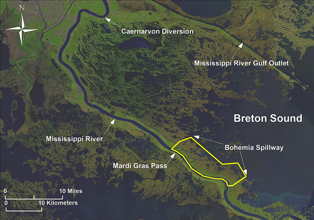
Mardi Gras Pass is located in the Bohemia Spillway, where the artificial river levees were removed in 1926 to relieve pressure on the Mississippi River levee system. This has allowed the river to flow over the natural levee during floods.
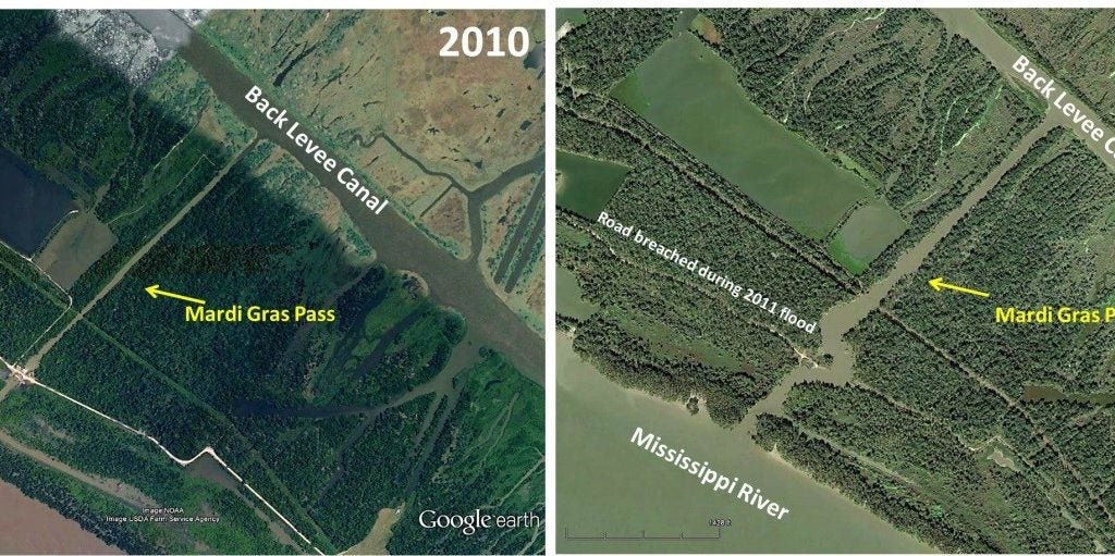
In 2011, the river formed a channel across the natural levee and washed away a section of road, connecting two pre-existing canals. The channel continued to erode and breached to the river again in 2012 around carnival time, and Mardi Gras Pass was formed – reconnecting the river to the wetlands in the area, resulting in new land formation in this area!
 Map of Breton Sound Estuary showing bounding water bodies as well as location of Mardi Gras Pass and Bohemia Spillway within the estuary. Credit: LPBF.
 Aerial view in 2010 (left) before Mardi Gras Passbegan to develop and in 2016 (right), which has grown by 13 acres since its inception in 2012. Credit: LPBF.
Sediment Distribution and Deposition
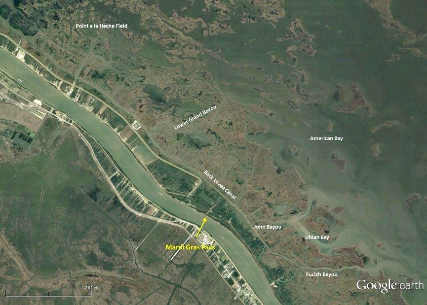
During high river flow, Mardi Gras Pass delivers fresh water, nutrients and sediment to 15,000 acres of coastal marsh through 36 pre-existing channels (natural and manmade). The Back Levee Canal is the most important and beneficial channel, because it disperses sediment into a network covering a very large area of marsh. Suspended sediment is deposited along the banks of this channel network because of reduced water flow velocity due to the increasing number of channel outlets. The large amount of sediment deposition in this area has even begun to infill obsolete oil and gas canals. The distribution system includes natural and manmade channels, but emulates a pattern similar to a natural deltaic distributary system.
 Flow distribution from Mardi Gras Pass. Water from the Mississippi River flow through Mardi Gras Pass (1st order channel) and is then distributed north and south in the Back Levee Canal (2nd order channel), and then flows into 3rd order channels like John Bayou, Fucich Bayou, Lower Grand Bayou or the Point a la Hache oil field. Flow then proceeds into open water bays or into higher order, smaller channels. The sediment plume from Mardi Gras Pass (muddy water) can be seen in the bayous and oil and gas field. Credit: LPBF.
Building New Land
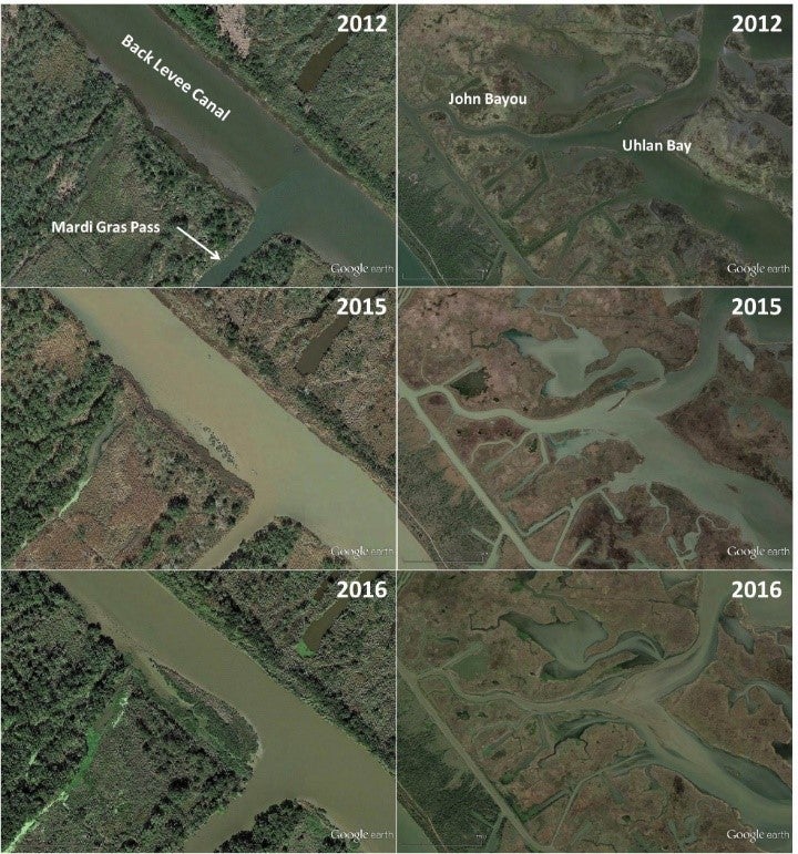
Mardi Gras Pass first built land in 2014, just two years after breaching to the river, and it has continued to build extensive shallow mud platforms that will likely become new wetlands. Widespread shallowing of the banks of canals and bayous due to sediment deposition has resulted in the formation of beds of submerged aquatic vegetation. This was observed in nearly all channels receiving discharge from the pass but was prominent in the Back Levee Canal, Fucich Bayou, John Bayou, William Boyles Canal, Spillway Canal and Lower Grand Bayou.
Land building that can be directly correlated to discharge from Mardi Gras Pass has been observed where the pass meets the Back Levee Canal. There also seems to be additional land building occurring in Uhlan Bay, which has become shallower and vegetation has emerged.
 Land Building at the mouth of Mardi Gras Pass (left) and shallowing and land building in Uhlan Bay (right). Credit: LPBF.
The surprising effectiveness of the Back Levee Canal to distribute water and sediment over a large area is a design consideration for outfall management of future sediment diversions. This design can help keep water levels lower, keep flow channelized and allow for more flexible adaptive management.
To learn more about Mardi Gras Pass and why it is important for restoration, read the full report from the Lake Pontchartrain Basin Foundation.