Mardi Gras Pass Showcases the Land-Building Power of the Mississippi River
In a stark contrast to what’s happening across the Louisiana coast, new land is forming along the east bank of the Mississippi River, 35 miles southeast of New Orleans. A new channel was opened between the Mississippi River and Breton Sound through the Bohemia Spillway. This new channel, dubbed Mardi Gras Pass, is the first distributary of the river to develop in decades.
During the 1920s, the levees in the area were removed to allow fresh water to overtop the land and relieve pressure on the Mississippi River levee system. Since then, a thick forest of oak trees has prospered in the area.
“This is some of the most beautiful land in Plaquemines parish,” says former Coastal Zone Program Manager Albertine Kimble who lives just upstream from the new land. “The river is the reason for that.”
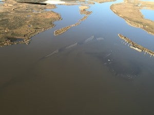
Aerial view of new land forming in Uhlan Bay. ©Richie Blink January 29, 2016.
The outlet was originally an outfall canal for a salinity control structure. In the Mississippi River flood of 2011, the river washed away a section of the road that follows the natural levee, connecting two sections of pre-existing canals from the salinity control structure. The channel continued to erode and breached to the river in 2012 around carnival time, and Mardi Gras Pass was formed – reconnecting the river to the wetlands in the area.
Right away, fresh water and sediment were able to benefit the area. Fishermen now catch freshwater bass alongside saltwater redfish. Manmade pipeline, navigation and oil and gas canals were filled in by the land-building power of the river. Sediment carried down by the river, through Mardi Gras Pass, settles to the bottom of bayous and bays creating new land.
On February 21, 2016, a photography service-learning class from Tulane University, led by Assistant Professor AnnieLaurie Erickson, in conjunction with Scott Eustis of the Gulf Restoration Network and Public Lab, chartered a boat to map the new land using helium-filled weather balloons. Downward-facing cameras were able to capture the new land that is already occupied by white pelicans and other shorebirds. The trip established baseline data showing how reconnecting the river to its delta can create land and benefit Louisiana’s coastal wetlands. This baseline data from Mardi Gras Pass is useful to inform future decisions regarding the construction and operation of controlled sediment diversion structures.
Check out some of these photos here:
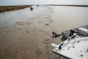
New land forming from river sediment in Bayou John. © AnnieLaurie Erickson February 21, 2016.
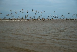
White Pelicans thriving on the newly formed land. © AnnieLaurie Erickson February 21, 2016.
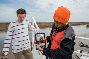
Cameras used to map new land forming in Bayou John. © AnnieLaurie Erickson February 21, 2016.
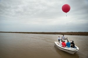
Cameras are attached to the weather balloon used to map the new land. © AnnieLaurie Erickson February 21, 2016.
As Louisiana continues to lose land at an astonishing rate every day, it’s important that we seek to understand and apply the best science from the areas gaining land across the coast. In addition to the extensive modeling and study executed by the State of Louisiana and U.S. Army Corps of Engineers to date, this science can help inform the development, construction and operation of controlled sediment diversions that will leverage the power and sediment of the Mississippi River to rebuild wetlands. Doing so will be crucial to protecting the people, wildlife and jobs that call coastal Louisiana home.
As the Plaquemines Community Outreach Coordinator for the Restore the Mississippi River Delta Coalition, Richie Blink works closely with local stakeholders to ensure widespread support of sustainable restoration of the Mississippi River Delta. Prior to joining the coalition Richie served as the Coastal Zone Program Manager with Plaquemines Parish Government to achieve a zero net loss of wetlands. He organized grassroots wetland restoration efforts that resulted in the planting of more than 15,000 cypress trees to reverse land loss and reduce storm surge near his hometown south of New Orleans. He serves as a board member of the Woodlands Conservancy, a nonprofit land trust organization focused on preservation of Louisiana’s coastal forest ecosystems. Richie served for three years on the Plaquemines Coastal Zone Advisory Committee which selects coastal restoration projects for implementation. In his free time, he guides motorboat tours into Louisiana’s coastal wetlands for Lost Lands Environmental Tours L3C. Always exploring, Richie holds a private pilot license and is a U.S. Coast Guard licensed captain.