Optimizing River Diversions in Order to Maximize Sediment Retention and Land Building
Over the last century, human engineering of the Mississippi River has greatly reduced the amount of sediment delivered to wetlands in the Mississippi River Delta. Half of the river’s sediment is trapped behind upstream dams and, in the lower river, levees block the rest of the sediment from reaching wetlands during floods.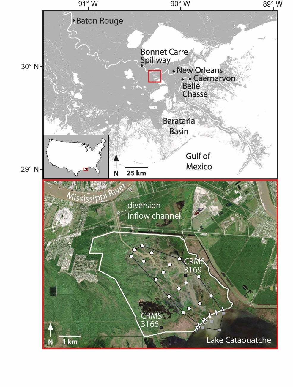 Yet, despite the river’s reduced sediment load, the rapid growth of the Wax Lake Delta in Louisiana’s Atchafalaya Basin shows that the remaining sediment in the Mississippi River is enough to build substantial amounts of land in targeted areas.
The remaining sediment in the Mississippi River is a critical resource for coastal restoration, especially for river diversions, which are a key tool to build and maintain land in southeast Louisiana. In order for river diversions to successfully restore land in the face of subsidence and rising sea level, as much of the river’s sediment as possible must be trapped in coastal wetlands rather than washing out into the Gulf of Mexico.
At the Davis Pond Freshwater Diversion, shown below, new land has emerged since construction was completed in 2002. New land is always great news for our eroding coastline, but it is especially interesting here because the Davis Pond diversion was NOT designed to build land – its primary purpose is to release freshwater into the interior wetlands of Barataria Bay to keep them from becoming too salty. Yet, land is growing.
What can we learn from Davis Pond to help design diversions that build even more land?

By studying Davis Pond, we discovered that moderate water flow (4,000-7,000 cubic feet per second compared to the diversion’s maximum flow of 10,000 cubic feet per second) seems to be optimal for land building in the diversion’s 9,000-acre ponding area. To build the most new land, diversions must maximize the amount of sediment delivered to wetlands while minimizing the flow rate of water that goes with it. It is a delicate balance. Water carries sediment, so the more water that is diverted, the more sediment enters the wetland. But, if too much water is diverted, the water will be flowing too quickly for the sediment to be deposited in the diversion’s ponding area.
What is the right flow of water?
To answer this question, we monitored water and sediment movement in Davis Pond before and after a two-week opening of the diversion in March 2015. During this opening, water flow increased from a background rate of about 1,000 cubic feet per second (cfs) to near maximum discharge of the diversion structure at 10,000 cfs. We found that during these two weeks, the wetlands received 41% of the total sediment for the year. This observation shows that floods are important mechanisms for getting sediment into wetlands.
How do we keep diverted sediment in wetlands?
Although a huge amount of sediment (117,700 tons) was delivered to the Davis Pond wetlands in the spring of 2015, less than half of that sediment (44%) was deposited in the ponding area northwest of Lake Cataouatche. The remainder washed through the ponding area to downstream parts of Barataria Basin. In contrast, in the fall of 2015, water discharge was back to its normal background rate of 1,000 cfs and sediment delivery dropped to one-third of what it had been in the spring (39,600 tons). However, the slower water flow meant that a whopping 81% of this sediment was retained in the ponding area.
Based on these observations, we built a mathematical model to calculate the optimum water flow that leads to maximum sediment deposition in the Davis Pond wetlands. The model, shown below, predicts that maximum deposition occurs when average water flow is about 4,000-7,000 cfs (100-200 cubic meters per second).

Although a flow of 4,000-7,000 cfs is much lower than the maximum capacity of the Davis Pond diversion (10,000 cfs), it is notably higher than the typical average flow (1,000 cfs). Even during the spring of 2015, which included the two-week diversion opening, average flow was only 2,200 cfs. In order to deliver more sediment to wetlands and build more land, discharge must be increased. This could be accomplished by either increasing the number of diversion openings per year (likely four would be needed) or by increasing the background flow rate of the diversion (to perhaps 4,000 cfs).
Determining the optimal flow for river diversions to maximize sediment deposition and retention is an important consideration for coastal restoration planners and engineers in Louisiana. This study’s results suggest that optimal flow regimes should be assessed for all future diversions, including the Mid-Barataria Sediment Diversion, which will have both a greater capacity and a larger ponding area than Davis Pond. Optimizing water flow will help maximize land building while managing sediment wisely across the system.