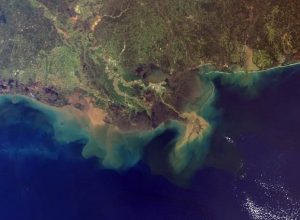
Figure 1. Satellite image of the Mississippi River Birdsfoot delta. Credit: NASA/GSFC/METI/ERSDAC/JAROS, and U.S./Japan ASTER Science Team.
In Louisiana, and in many places, the term “delta” is widely used. That’s mainly because we live on a delta – the Mississippi River Delta – and much of the land that comprises coastal Louisiana was built by the Mississippi and other rivers creating new deltas over millennia.
From a more technical standpoint, identifying what a delta is and its various components may not be as easy for most people. Many people picture a delta as a place where a river meets open water, and land protrudes outward as sediment accumulates near the mouth. What some may not know is that there is more to a delta than what we see in satellite images. Some of the most important parts of a delta are below the surface.
Jump to a section:
-
-
- The Parts of a Delta
- The Types of Sediment: The Building Blocks of New Land
- Why What You Can’t See Is Important
- References
The Parts of a Delta
Much like a glacier, most of a delta’s anatomy can be found below the water’s surface (called subaqueous). So what are the various parts that comprise a delta?
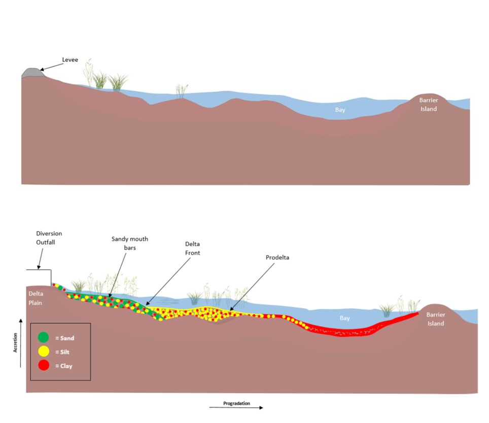
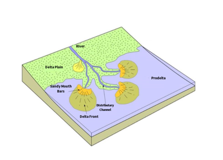
- The delta plain is a visible, broad, low-lying land mass where a river empties into a body of water. The sediment is transported to an open body of water (like the Gulf of Mexico) via distributary channels that stem off from the main river route. The remaining components become subaqueous and only the shallowest are visible in satellite imagery.
- A mouth bar is created when the distributary channel ends and water speed decreases, resulting in deposition of sediment.
- At the bottom of the slope is the delta front. The front is a shallow, subtidal portion of the delta where erosion and/or deposition and waves/tides are present.
- The prodelta is farther offshore and deeper below the influence of waves or tides. Here, sediment deposition is slowest and consists of the finer and lighter particles deposited from the river.
Deltas, like the Mississippi River Birdsfoot Delta, are river-dominated ecosystems. A river-dominated delta is only partially influenced by tides and waves. In this instance, wave energy dissipates before connecting with the coastline. These delta types are formed by sediment transport and deposition, also known as “fluvial processes.” As sediment is carried into the water column, it makes the way to the mouth of the river, where it is distributed and fans out like water from a hose laid in your yard. The distance that the sediment travels is based on the characteristics of the sediment (size and composition) and the speed at which it is carried. Distributary channels help to build out the delta lobes over time as sediment is reworked by tides and waves.

Figure 3. Depiction of a delta complex with a transect running from the Mississippi River and the levee system to the barrier islands. The first transect depicts a conceptual outcome with no diversion structure. The second depicts a conceptual outcome with a sediment diversion and the subaqueous development of a deltaic system consisting of sands, silts and clays.
The Types of Sediment: The Building Blocks of New Land

Figure 4. Illustration of sediment size between sand, silt and clay. Clay is typically defined as particles less than 0.00195 mm in diameter, and sand reaching up only to 1.5 mm in diameter with silt falling in between (modified from Fondriest).

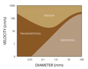
Figure 5. Sediment size and water velocity determine whether sediment will be transported, eroded, or deposited. (Credit: Fondriest Environmental, Inc.)
Sediment type plays a major role in delta formation. Sediment in the Mississippi River Delta (MRD) is predominately sand, silt and clay, with sand being the coarsest and clay being the finest. Fine sediments like clays and muds are highly mobile and tend to travel the farthest distance; they also make up nearly 80% of the sediment load in most rivers1. The ability of sediment to be transported, eroded or deposited is a function of its size and the speed of the water flow2.
In the case of the proposed sediment diversions in Louisiana’s Coastal Master Plan, moving sediment is important for rebuilding wetlands in the MRD. Sand contributes to increasing elevation, while silts and clays are needed to help sustain the land being built4.
Why What You Can’t See Is Important
Louisiana’s Coastal Master Plan proposes multiple sediment diversions to mimic the natural land-building processes of a delta. For every project, the Coastal Master Plan estimates the amount of acres created and sustained by the restoration activity. For sediment diversions, it’s important to remember that the total acreage reported is only what can be seen above the water line.
The Wax Lake Delta is a great example of how successful these projects can be. In order to reduce flooding for nearby communities, the U.S. Army Corps of Engineers created a shortcut via a dredged outlet from the Atchafalaya River to the Gulf of Mexico in 1941. In doing so, Atchafalaya Bay began to fill with sediment, forming the Wax Lake Delta. This was an unintended side effect of a project aimed at reducing flooding in adjacent communities and ended up being a successful engine of natural land building. Even after major storms like Hurricane Katrina have caused land loss in the Wax Lake Delta, the natural deltaic processes present there have made the surrounding wetlands more resilient, enabling them to bounce back faster7.
 It’s not uncommon or abnormal for large deltas to experience major transformations over time – they are by their very nature dynamic systems. Reduced sediment supply, sea level rise acceleration and subsidence have all contributed to the changes in the MRD, causing land to sink or disappear entirely. In contrast, areas like the Wax Lake Delta, or where sediment diversions will be operating, have the potential for regular accretion of sediment. This allows vegetation to grow and establish itself, which can increase the ability to trap sediment for continued land-building7. Vegetation can decrease water speed and bank erosion by creating flow resistance and stabilizing sediments3. The land growth occurring in the Wax Lake Delta is so significant that it has the ability to support large vegetation such as willows and reeds to colonize the higher elevations and nearby sandbars of the delta. According to scientists, this shows the adolescence of the delta. Willows provide not only protection against storms and reduce erosion, but also valuable habitat for a variety of animals including rabbits, birds and deer6.
Figure 6. Satellite image of the Mississippi River delta showing sediment being wasted off the coast and into the Gulf of Mexico.
It’s evident that land loss extends beyond what we can see at the surface. Less sediment is reaching areas that need it most in places, like the Barataria and Breton Basins. At the same time, too much of that sediment is being wasted and exported offshore as a result of levees, dams and canals. Now more than ever, sand and silt is needed to build out a subaqueous delta and accrete over time to fight off future land loss from sea level rise and subsidence – a diversion can do just that, if operated correctly.
References
1Esposito, C.R., Z. Shen, T.E. Tornqvist, J. Marshak, & C. White (2017). Efficient retention of mud drives land building on the Mississippi Delta plain. Earth Surf. Dynam., 5, 387-397.
2Fondriest Environmental, Inc. “Sediment Transport and Deposition.” Fundamentals of Environmental Measurements. 5 Dec. 2014. Web. < https://www.fondriest.com/environmental-measurements/parameters/hydrology/sediment-transport-deposition/ >.
3Lauzon, R., & A.B. Murray (2018). Comparing the cohesive effects of mud and vegetation on delta evolution. Geophysical Research Letters.
4Nichols, G. (2009). Sedimentology and Stratigraphy. Retrieved from https://raregeologybooks.files.wordpress.com/2014/09/sedimentology-and-stratigraphy-by-gary-nichols.pdf.
5Nittrouer, J.A. & E. Viparelli (2014). Sand as stable and sustainable resource for nourishing the Mississippi River delta. Nature Geoscience, 7, 350-354.
6Nobel, J. (2016, May 12). The Birth and Death of a Landscape – Issue 36: Aging. Retrieved from http://nautil.us/issue/36/aging/the-birth-and-death-of-a-landscape.
7Rosen, T. & J. Xu (2013). Recent decadal growth of the Atchafalaya River Delta complex: Effects of variable riverine sediment input and vegetation succession, Geomorphology, 194, 108-120.
8Wagner, W., D. Lague, D. Mohrig, P. Passalacqua, J. Shaw, & K. Moffett (2017). Elevation change and stability on a prograding delta. Geophys. Res. Lett., 44, 1786–1794.
-
