A Tale of Two Basins: Why One is Thriving While the Other is Dying
To understand the issues of land loss affecting Louisiana’s coast and the restoration solutions needed to address it, one needs only compare two neighboring basins on the coast. In the Atchafalaya Basin, lush, green fingers of land push out toward the Gulf of Mexico, building more and more acreage every year. In the Terrebonne Basin to the east, land is rapidly disappearing at one of the highest rates on the planet.
Why are there such stark differences between these two basins that are geographically so close together? What can these basins teach us about efforts to restore Louisiana’s coast?
The key to successful, ongoing land-building in the Atchafalaya Basin is the steady flow of sediment and fresh water the area receives from the Atchafalaya River and the Wax Lake Outlet. In contrast, there is little fresh water and almost no sediment input to most of the Terrebonne Basin, contributing to continued and severe land loss.
As it always has, rivers and their freshwater and sediment are key to building and sustaining land across coastal Louisiana. Finding ways to use rivers to restore the coast will be essential to maintaining the region.
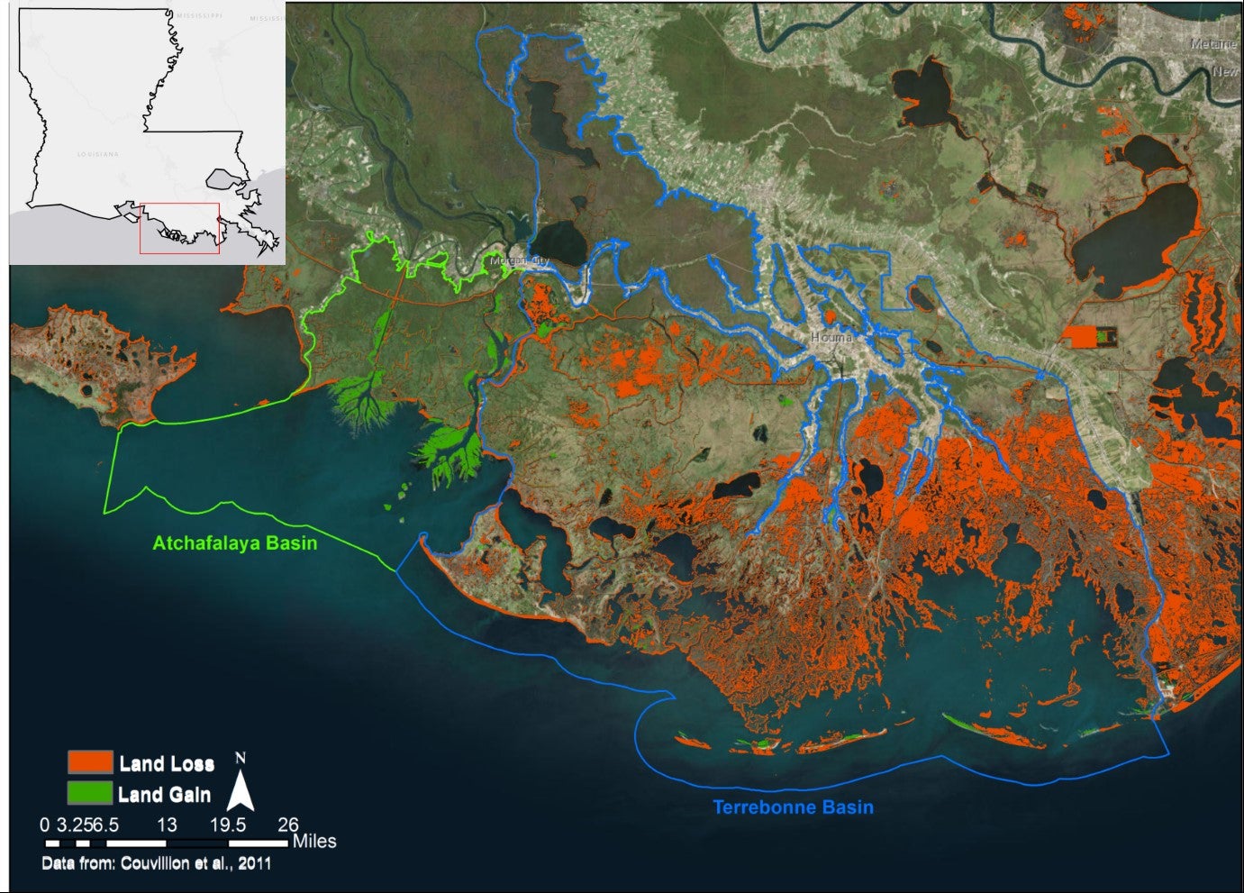
Land change in the Atchafalaya and Terrebonne basins, 1932-2016.
The Atchafalaya Basin
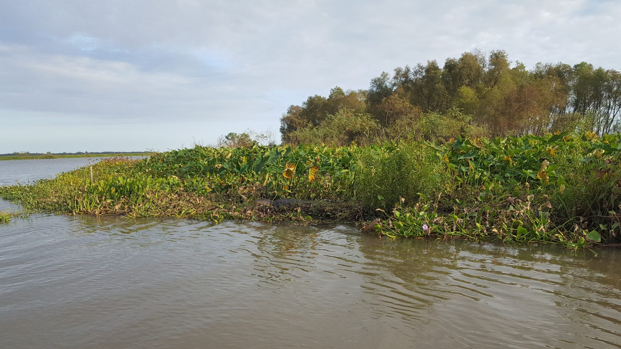
New land emerging in the Wax Lake Delta.
Between 1932 and 2016, while every other basin in Louisiana was losing land, the Atchafalaya Basin gained more than six square miles (4,000 acres) of wetlands.1 The Atchafalaya River is the last major distributary of the Mississippi River, and it receives, on average, 30 percent of the combined flow of the Mississippi and Red Rivers or around 300,000 cubic feet of water per second.2
In 1942, the Army Corps of Engineers dredged a channel from the Atchafalaya River to the Gulf of Mexico to decrease water levels moving past Morgan City, splitting the flow of water and sediment between the Atchafalaya River and the Wax Lake Outlet. Over time, sediment filled in the Wax Lake, and the Wax Lake Delta emerged. A delta has also been built by the Atchafalaya River, but unlike the all-natural Wax Lake Delta, this delta has been augmented by dredging of the Atchafalaya River and disposal of this sediment.
The constant stream of sediment into the broad, shallow Atchafalaya Basin has resulted in this being the only basin in Louisiana experiencing net land gain. This new land pushing out into the Gulf has continued over the years, despite experiencing challenges affecting many areas of Louisiana’s coast, including subsidence, sea level rise, hurricanes and more.
The land built and sustained by the Wax Lake Outlet is swamp and marsh habitat that is teeming with life, and the Wax Lake Delta is a picture of a living, thriving delta.
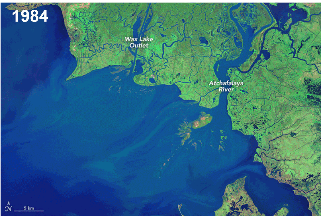
Land building in the Wax Lake Delta from 1984 to 2015.
The Terrebonne Basin
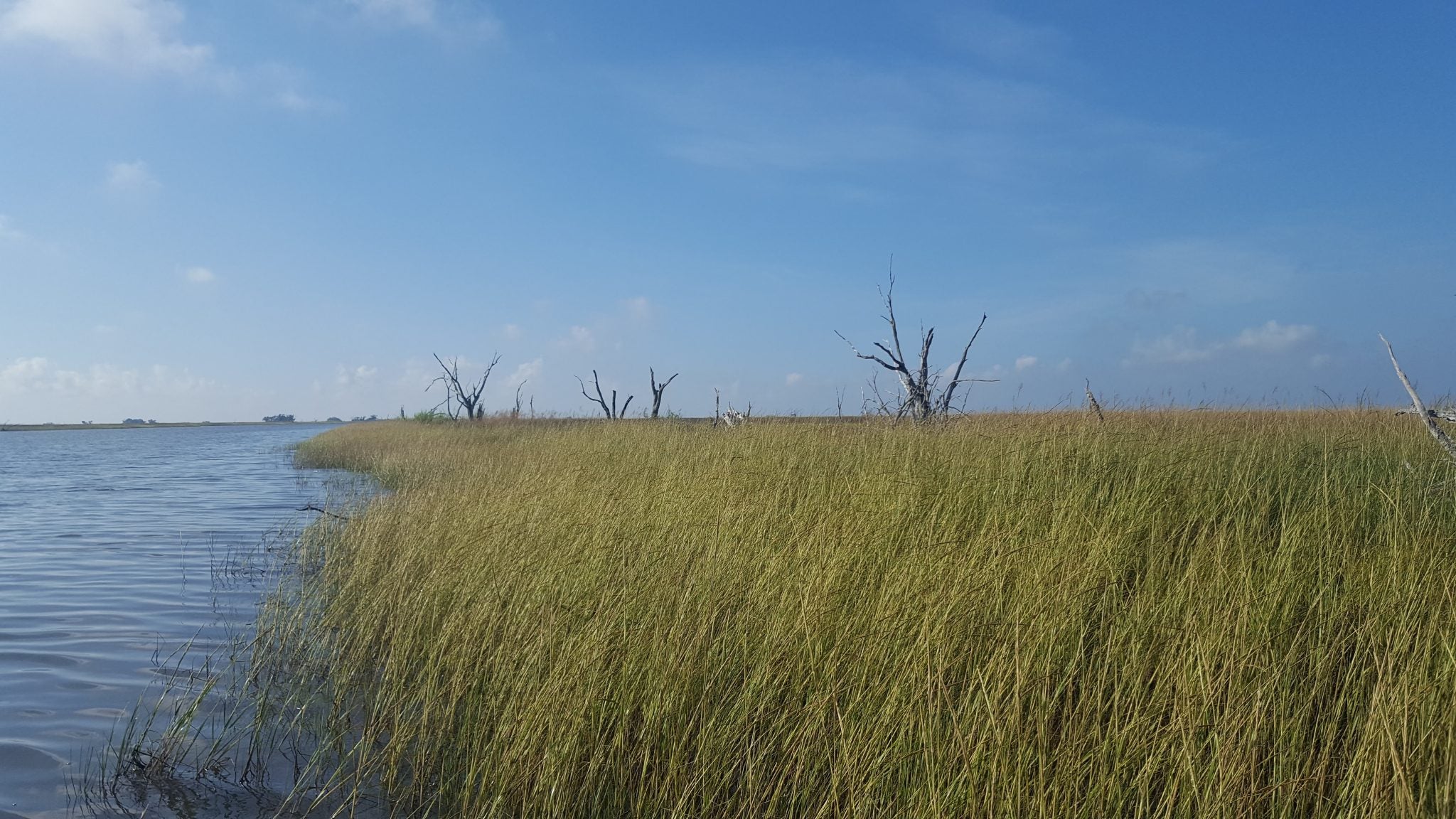
Dying wetlands in the Terrebonne Basin near Cocodrie, LA.
In stark contrast, between 1932 and 2016, the Terrebonne Basin lost more than 500 square miles (300,000 acres) of wetlands. This basin is the remnants of an old delta complex that was formed when the main flow of the Mississippi River emptied into this area 500-2,500 years ago.3
When the French arrived in Louisiana, Bayou Lafourche was the major distributary of the Mississippi River, and along with other smaller channels, such as Bayou Terrebonne, carried fresh water and sediment to the Terrebonne Basin that helped nourish and maintain its wetlands.4
A dam was completed across Bayou Lafourche in 1904 to prevent flooding at Donaldsonville, but this dam also cut off the steady flow of fresh water and sediment to the wetlands. Eventually, in order to address stagnation and pollution in the bayou and to push back against saltwater intrusion from the Gulf, a pumping plant was put in place to pump and siphon water from the Mississippi River into Bayou Lafourche to address fresh water needs, stagnation and pollution in the bayou,.5
Today, the Terrebonne Basin receives fresh water and some sediment from the Atchafalaya River on the western side of the basin, and, when Atchafalaya river stages are high, some of the fresh water from the Atchafalaya reaches the central part of the basin through the Gulf Intracoastal Waterway.6 However, the Terrebonne Basin is still largely sediment and freshwater poor, contributing to ongoing land loss. The lack of sediment input in the Terrebonne Basin, among other factors, has led to a disintegration of the productive and protective wetlands of Terrebonne, leaving coastal communities, industry and vital infrastructure increasingly vulnerable to storms.
Restoring and Sustaining the Terrebonne Basin
A suite of restoration solutions is needed to restore and sustain wetlands in the Terrebonne Basin. But key to building and sustaining land over the long-term is effectively using the fresh water and sediment of the Atchafalaya River.
Projects such as the Atchafalaya River Sediment Diversion and the Increase Atchafalaya Flow to Terrebonne Diversion, along with the Houma Navigation Canal Lock Hydrologic Restoration, would increase the flow and retention of fresh water eastward to the central part of the basin to sustain existing marshes. Other projects, like the Mauvais Bois and Bayou DuLarge ridge restoration projects, marsh creation projects, and restoration of the Terrebonne Basin’s barrier islands, would also help restore and sustain the area.
As Louisiana’s coast continues to lose a football field every 100 minutes, one need only contrast the thriving Atchafalaya Basin and the dying Terrebonne Basin to see how important directing freshwater and sediment, through sediment diversion and other projects, will be to maintaining land along our coast.
1 Couvillion, B.R., Beck, Holly, Schoolmaster, Donald, and Fischer, Michelle, 2017, Land area change in coastal Louisiana 1932 to 2016: U.S. Geological Survey Scientific Investigations Map 3381, 16 p. pamphlet, https://doi.org/10.3133/ sim3381.
2 U.S. Geological Survey, 2018, National Water Information System data available on the World Wide Web (USGS Water Data for the Nation), accessed [April 27, 2018], at URL [https://waterdata.usgs.gov/la/nwis/uv/?site_no=07381482&PARAmeter_cd=00065,72020,63160,00060].
3 Michael D. Blum and Harry H. Roberts. 2012. The Mississippi Delta Region: Past, Present, and Future. Annual Review of Earth and Planetary Sciences 2012 40:1, 655-683
4Muth, D.P. 2014. “The Once and Future Delta.” Perspective on the Restoration of the Mississippi Delta. Ed. J.W. Day, G. P. Kemp, A.M. Freeman and D.P. Muth. Dordrecht: Springer. 9-28.
5 Doyle, H.W. 1972. Sediment transport in a Mississippi River distributary: Bayou Lafourche, Louisiana. U.S. Government Printing Office, USA.
6 Reed, D. J. , Ed. 1995. Status and Historical Trends of Hydrologic Modification, Reduction in Sediment Availability, and Habitat Loss/Modification in the Barataria and Terrebonne Estuarine System. BTNEP Publ. No. 20, Barataria-Terrebonne National Estuary Program, Thibodaux, Louisiana, 338 pp. plus Appendices.