Hydrocoast Maps Monitor Changes in Mississippi River Estuaries
By John Lopez, Ph.D., Coastal Sustainability Program Director, Lake Pontchartrain Basin Foundation
The Lake Pontchartain Basin Foundation (LPBF) is releasing a report describing the methodology of its Hydrocoast Maps program, a research effort that began in 2012 and monitors water flow, salinity and other factors to better understand the Mississippi River estuary in the Pontchartrain Basin.
What are the Hydrocoast Maps?
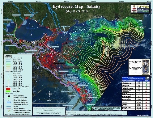
Hydrocoast Map
The Hydrocoast Maps monitor the distribution of salinity, changes in water quality, and other pertinent information across the Pontchartrain Basin to provide an ongoing, relevant and accurate assessment of basin conditions. LPBF produces a biweekly map series that displays information on salinity, freshwater discharge, water quality, impairments, fisheries activity and a variety of estuarine-related information.
The Hydrocoast Maps provide a snapshot of the condition of the estuary, such as the distribution of saline to fresh water and other relevant factors. LPBF’s goal is for the maps to be useful to a diverse audience – including the general public, but more specifically commercial and recreational fishers, state and federal agency personnel making restoration decisions, scientists and academics.
The biweekly Hydrocoast Map products, and what they analyze, include:
- Salinity Map – isohalines (lines on maps connecting points of equal salinity) and freshwater inflows
- Biological Map – fisheries fleets and closures
- Habitat Map – wetland classification and soil salinity
- Water Quality Map – water quality impairments and fecal coliform counts
- Weather Map – cumulative rainfall, wind and tide data
Current and archived Hydrocoast Maps can be found here.
The Mississippi River Estuary
On the Louisiana coast, fresh water from rainfall and rivers flows seaward and mixes with salt water from the Gulf of Mexico, resulting in a coastal zone called an estuary. This estuarine system also coincides with the extensive deltaic (wetland) plain of the Mississippi River and gives rise to Louisiana’s valuable and productive “working coast.” There are many factors that affect this estuary, such as pollution, fisheries, hydrologic alterations, wetland loss and freshwater inflows. These influences are dynamic and the estuary is shifting daily, but it is also undergoing long-term changes. For example, since 1932 these wetlands have been converting to open water at an unnatural and alarming rate, giving rise to Louisiana’s coastal wetland crisis.
Understanding all of these natural and manmade influences on the estuary is important for local recreational and commercial fisheries, as well as for restoration scientists who may gain a deeper understanding of how the estuary functions and its trajectory of change. Change is inevitable, but we should use the best available data to work with the deltaic system and bring about comprehensive restoration of the Mississippi River Delta