LPBF Assesses Upgraded Hurricane Protection System for Greater New Orleans Eastbank
By Ezra Boyd, PhD, Disastermap.net, LLC
The Hurricane Surge Risk Reduction System
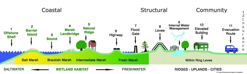
As we approach the 10th anniversary of Hurricane Katrina and the associated levee failures, the people of the Greater New Orleans (GNO) region face constant reminders that our safety and viability depend on a complex system made of numerous elements that together mitigate risks from hurricane induced tidal floods. The near constant construction of levees, pumps and floodgates over the last decade provides the most visible evidence of this system. Together, these components are termed the structural lines of defense. In addition, work on other important, but less visible, components have also reduced our flood risk. Broadly speaking, the other two major components are the coastal lines of defense and the community lines of defense. Together, these three components comprise the Multiple Lines of Defense Strategy for Sustaining Coastal Louisiana (MLODS).
Beyond a list of 12 separate lines of defense (see figure below), MLODS represents a system that allows us to use the professional tools and standards of systems engineering to assess the current status of storm surge risk reduction. Within the field of systems engineering, a system is defined as: “an integrated set of elements, segments and/or subsystems that accomplish a defined objective.” The 12 lines of defense make up the elements of the system, and systems engineering helps us figure out if they function in an integrated fashion to accomplish the objective of managing storm surge risk.
A recent report from the Lake Pontchartrain Basin Foundation, called “A Systems Engineering Based Assessment of The Greater New Orleans Hurricane Surge Defense System Using the Multiple Lines-of-Defense Framework,” provides a detailed assessment of the current system of levees, pumps, gates, coastal landscape features and community resilience steps that the region depends upon to manage storm surge flooding risk.
System Interactions and Factors of Concern
Once the Hurricane Surge Defense System (HSDS) has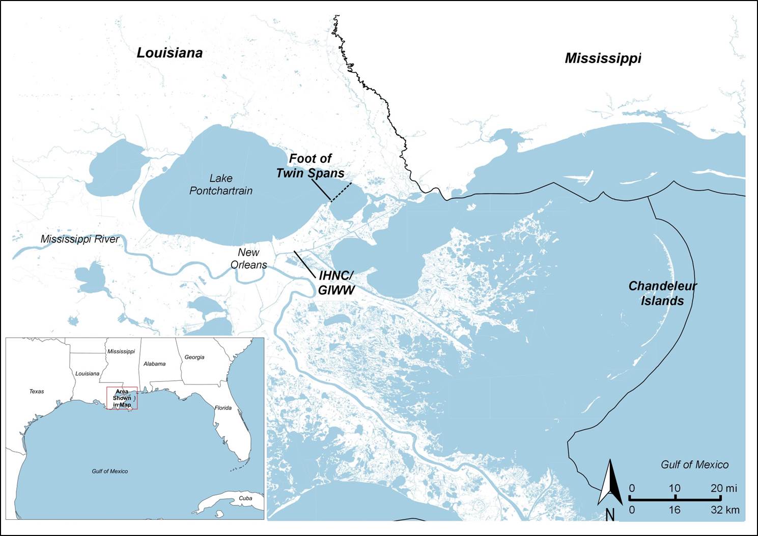 been specified as a system, the tools of systems engineering then allow us to identify system interactions that create major factors of concern. A system interaction refers to when the performance of one system element is impacted by the other elements, while a factor of concern is an element or interaction between elements that could potentially reduce the system performance. The report identified and described a number of system interactions and factors of concern. Two of the major concerns are with the Foot of the Twin Spans bridge and the IHNC/GIWW navigation canal (shown here). Both result from interactions between systems elements that affect evacuation effectiveness.
I-10 East Evacuation Route & Chandeleur Islands
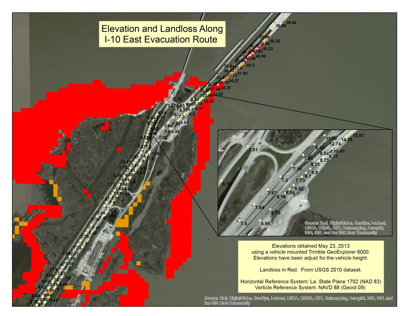 Interstate 10 is a major evacuation route. During peak evacuation, an estimated 2,000 vehicles per hour utilize its eastbound lanes to escape GNO. These eastbound lanes cross Lake Pontchartrain on the edge of New Orleans. Since Hurricane Katrina, the bridge, locally known as the “Twin Spans”, has been rebuilt in an $800 million project that raised the bridge to 30 feet above sea level. Not far from the bridge is the rebuilt levee system that provides perimeter protection for GNO. Between the levee and foot of the bridge is an approximately 1 mile section of interstate that is at ground level and outside the levee system. Most of this section of highway is 7 – 8 feet above sea level. However, just before the foot of the bridge, atop of narrow peninsula that has experienced landloss on all three sides, the highway dips to around 6.7 feet above sea level. This low, unprotected section of a major evacuation route is prone to flooding early during storm surge events, thus blocking any further evacuation.
The Chandeleur Islands, a rapidly eroding barrier island chain, are located some 60 miles from the foot of the Twin Spans bridge. Yet, how they perform as a coastal line of defense affects the performance of the I-10 East evacuation route. Hydrological studies have determined that the elevation and integrity of the Chandeleurs influences the timing and height of the peak surge, with the surge peaking 1.5 feet higher and 1 hour sooner if the islands continue to erode. Exemplifying the concept of system interactions, the Chandeleur’s ability to mitigate storm surge impacts the available window of time to evacuate people using the eastbound I-10.
IHNC/GIWW Closure Operations, Vessel Evacuation, and Vehicular Evacuation
The Inner Harbor Navigation Canal (IHNC) and Gulf Intracoastal Watery (GIWW) are two manmade navigation canals within the eastern half of GNO. During Hurricane Katrina, they were major conveyance pathways for storm surge and also the location of numerous levee breeches. Since Hurricane Katrina, the area has been subject to major levee upgrades along with newly constructed floodwalls and floodgates. While these structural improvements provide a potentially much improved level of protection, the gates in particular create a new set of concerns related to system behavior. They also provide another example of asystem interaction that also affects evacuation effectiveness.
Simply put, closing the gates in anticipation of a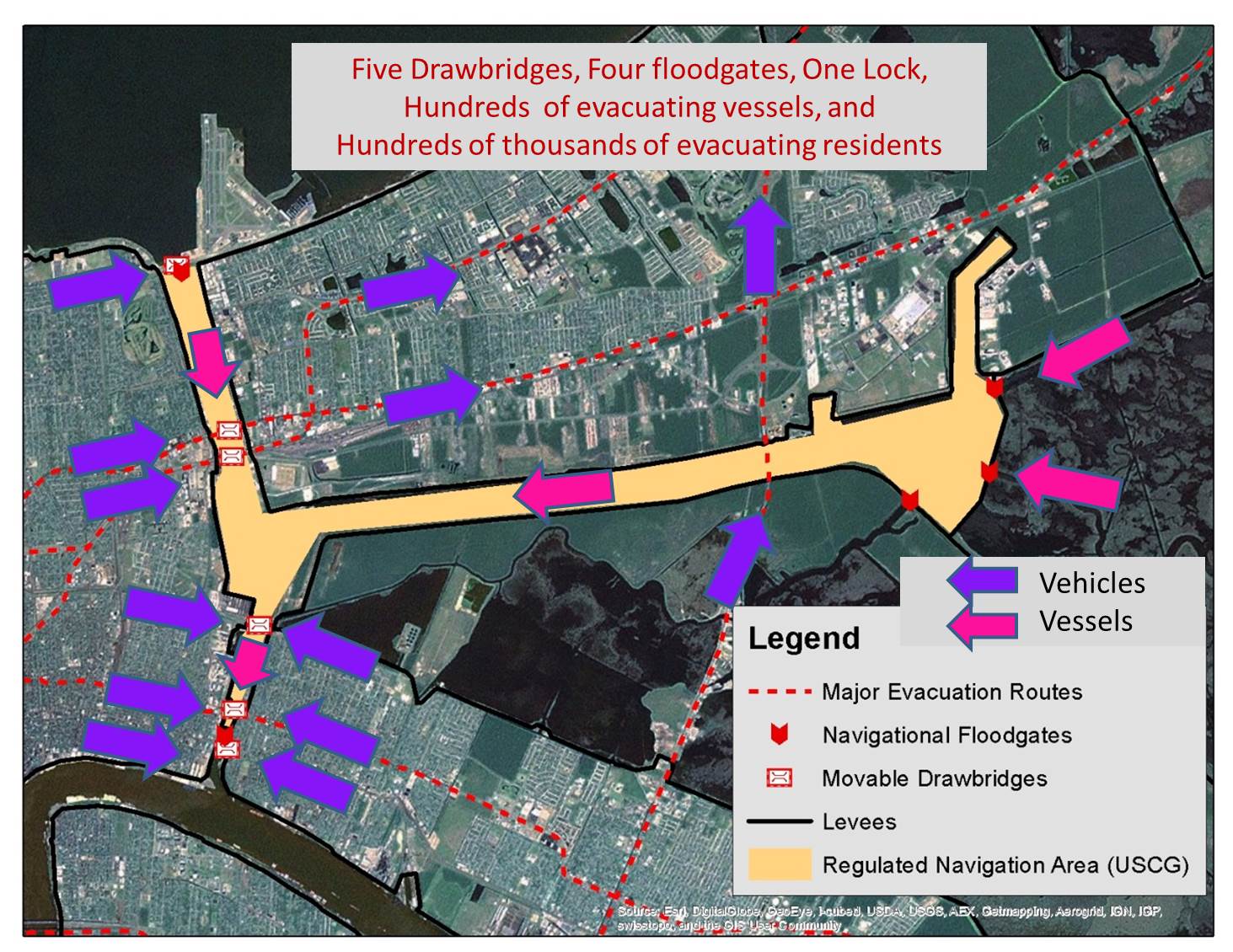 tropical system is a complicated procedure that must be coordinated with navigational interests, railroads, and the Port of New Orleans. Most navigational vessels are required to evacuate the IHNC/GIWW before a hurricane. This in-turn requires that the vessels pass under a number of drawbridges. Since the drawbridges must be opened to let vessels pass, they then hinder vehicular evacuation of the general population. Here the operations of these structural components (the flood gates along these two canals) impact the performance of the evacuation component, another example of a system interaction that creates a major factor of concern.
Conclusion
These are just two of many factors of concern with the current HSDS. Our report documents others, some small and others major. Maintenance, long term funding, coordination, and public risk communication were the major themes uncovered in our study. Because it is important for the public and policymakers to understand the true level of protection, LPBF continues to build on the momentum create by this report. As step toward addressing some of the issues identified in the report, we have recently launched the Pontchartrain-Maurepas Surge Consortium to facilitate regional collaboration between levees boards, floodplains managers, coastal scientists, and others engaged in storm surge management and risk reduction.
The report, along with LPBF’s continuing efforts at implementing MLODS for coastal flood protection, has been funded by the Kresge Foundation.
Additional resources:
LPBF’s Systems Engineering Report
Systems Engineering Presentation to Southeast Louisiana Flood Protection Authority-East
International Council on System Engineering (INCOSE)
Hydrological Study of Chandeleur Islands Impact of Storm Surge