Understanding Social Vulnerability in Your Community
The paradox at hand
Over 2.3 million people live in the 20 parishes located in Louisiana’s Coastal Zone. According to the most recent National Coastal Population Report, a collaboration between the U.S. Census Bureau and NOAA, the rate of population increase in coastal Louisiana has doubled since 2010.
Unfortunately, coastal land is disappearing as the population grows. A football field of wetlands disappears every 100 minutes (USGS). Restoration projects aim to preserve and rebuild the state’s beautiful wetlands, which provide habitat and serve to protect the vibrant and diverse lifestyles of coastal Louisianians.
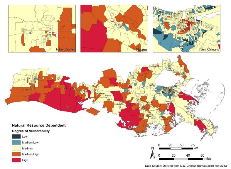
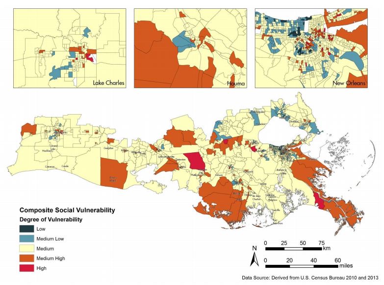
The state’s 2017 Coastal Master Plan evaluates community susceptibility to environmental threats using a metric called the Social Vulnerability Index (SVI). The SVI combines demographic factors such as age, race, gender, socioeconomic status, special needs and profession to develop vulnerability scores that can be used to compare different groups of people. Demographic factors predict vulnerability to a variety of threats, so the SVI can be applied to natural and anthropogenic hazards, including hurricanes, oil spills and sea level rise. High scores mean that populations with a low capacity to cope with hazards, while populations with low scores are well-suited for adaptation to such disturbances.
 Location of Golden Triangle Marsh Creation and New Orleans East Landbridge between Lakes Pontchartrain and Borgne in Orleans Parish. [Credit: Lindsay Nakashima]

Who’s at risk?
According to the SVI analysis in the master plan, rural parishes and parishes bordering the Gulf of Mexico or the Atchafalaya Basin have the highest vulnerability. The least vulnerable parishes are largely suburban areas outside cities. Scores averaged at the parish level suggest that parishes located along the western part of the Louisiana coast are less vulnerable than parishes located along the central and eastern parts of the coast.
Despite these general trends, nuances clearly exist at the community level. Communities that are economically dependent on natural resources, such as fisheries, are especially vulnerable to hazards. These communities are predicted to have limited capacity for economic recovery in the face of rapidly degrading resources. Plaquemines and Vermillion parishes both contain highly vulnerable, resource-dependent populations.
Metropolitan areas encompass both very low and very high risk communities. New Orleans is densely populated and economic opportunity attracts a diversity of socioeconomic and racial groups to the city. However, areas of the city populated by minority groups of low socioeconomic status are highly vulnerable, while areas populated by wealthy, majority racial groups are not as vulnerable. This variability requires hazard plans and resources that are inclusive of all racial and socioeconomic groups, but it also provides opportunities for communities to support one another.
Building resiliency
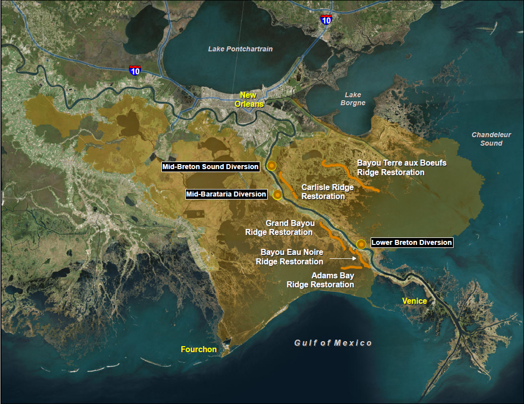
Fortunately, many of the state’s planned restoration projects from the 2017 Coastal Master Plan will have direct positive benefits to some of the most vulnerable parishes. New Orleans East Landbridge Restoration and Golden Triangle Marsh Creation, both large-scale marsh creation projects slated for near-term development, will buffer storms and decrease coastal flooding in Orleans Parish. In Plaquemines, a number of important projects are planned for the next ten years. Several ridge restoration projects, including Bayou Terre aux Boeufs Ridge Restoration and Adams Bay Ridge Restoration, will build around 560 acres as soon as they are constructed. The Lower Breton Diversion, Mid-Breton Sound Diversion and Mid-Barataria Diversion will collectively build nearly 55,500 acres over the 50 years following their construction.
Protecting Louisiana’s coastline with a diversity of restoration projects increases the resiliency of coastal communities by restoring ecosystem services. The SVI enables the state to compare vulnerability across communities. Though not currently used as a decision-making tool, the SVI can help inform state officials about which projects to fund and prioritize based on the benefits they provide with regard to hazard mitigation and adaptation. You can learn more about social vulnerability and the SVI by following the links below.
Click here to learn about vulnerability in your community and along the Louisiana coastline using CPRA’s new interactive tool!
Click here to view the results of CPRA’s SVI analysis.
_____________________________________________________________________________________
Attachment A8: Project Fact Sheets. (2017). In Louisiana’s Comprehensive Master Plan for a Sustainable Coast (pp. 1–294). Baton Rouge, Louisiana: Coastal Protection and Restoration Authority of Louisiana. Retrieved from http://coastal.la.gov/wp-content/uploads/2017/04/Attachment-A8_FINAL_05.17.2017.pdf
Attachment A9: Parish Fact Sheets. (2017). In Louisiana’s Comprehensive Master Plan for a Sustainable Coast (pp. 1–52). Baton Rouge, Louisiana: Coastal Protection and Restoration Authority of Louisiana. Retrieved from http://coastal.la.gov/wp-content/uploads/2017/04/Attachment-A9-Parish-Fact-Sheets_FINAL05.24.2017.pdf
Attachment C4-11.2: Social Vulnerability Index. (2017). In Louisiana’s Comprehensive Master Plan for a Sustainable Coast (pp. 1–28). Baton Rouge, Louisiana: Coastal Protection and Restoration Authority of Louisiana. Retrieved from http://coastal.la.gov/wp-content/uploads/2017/04/Attachment-C4-11.2_FINAL_030817.pdf
National Coastal Population Report: Population Trends from 1970 to 2020. NOAA and U.S. Census Bureau, 2013. Web.
USGS: Louisiana’s Rate of Coastal Wetland Loss Continues to Slow. (2017, July 12). Retrieved July 21, 2017, from https://www.usgs.gov/news/usgs-louisiana-s-rate-coastal-wetland-loss-continues-slow