A Mini-Diversion in Boston is Paving the Way for Louisiana’s Boldest Coastal Project
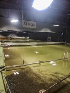
Based in Holden, MA, Alden Labs has built a physical model of a portion of the Mississippi River to better understand the impacts of the Mid-Barataria Sediment Diversion. Photo by David Muth
When imagining people and places linked to restoring coastal Louisiana, a group of scientists and engineers sitting in a lab in the suburbs of Boston probably won’t come to mind.
Yet, that’s exactly where a group of Restore the Mississippi River Delta staff, including me and one 10-year old budding scientist, found ourselves as we toured an innovative, large-scale physical model of the Mississippi River and the Mid-Barataria Sediment Diversion.
Land loss in the Barataria Basin – and throughout southeast Louisiana – is far-reaching and, in some places, irreversible. With the increasing threat of sea level rise from climate change and subsidence, we must come to a shared understanding that an innovative solution to coastal land loss is needed, and it is needed now.
Large-scale solutions like the $1.4 billion Mid-Barataria Sediment Diversion project, which use the power of the Mississippi River itself to build land, mimic the natural processes of the river to deliver sediment and fresh water to nearby wetland and marsh areas. It gives vegetation a chance to take root and ultimately building new land.
Sophisticated numerical modeling results predict that this diversion can keep up with sea level rise in the future or even increase the area of landscape at the Barataria basin-wide level if running continuously for 50 years while working in concert with the Coastal Protection and Restoration Authority’s (CPRA) ongoing marsh creation work.
A Miniature Mid-Barataria
Alden Lab, a hydraulic engineering lab in Holden, MA, worked with CPRA to model the diversion, part of the area around its outfall and the section of the river near the project.
Designed 65 times smaller than what will be the real diversion, the lab uses the physical model to supplement the computer models. The “mini diversion” provides additional insight for changing conditions by measuring variables that can’t be adequately captured in a numerical model.
Those variables include the sediment to water ratio, evaluating the sediment that builds up downstream, measuring water speeds near the intake and head-loss — the height difference that allows the water to flow — while moving through the gate structure. In the channel, they can see how features form on the bottom of the river with the water’s movement and more.
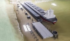
A scaled-down barge sits docked along the banks of the Mississippi River model. Photo by David Muth.
Before the tour, Alden Vice President Dr. Dan Gessler presented how the engineers built the physical model. They faced unique challenges like trying to find a way to scale down already small particles of sand and finer sediment that could still demonstrate similar properties while suspended in water.
After receiving safety instructions, we all headed out to see the diversion model at work. The impressive 14,000 square-foot model is housed inside a building on a 30-acre property. The scaled-down version of the Mississippi River even includes a barge docked at the bank.
A squirt of red dye into the riverside of the model revealed how water and sediment entered the diversion’s gates, flowed into the channel and disappeared into what would be wetlands in real life. My daughter was the first to try this out. A look of wonder appeared in her eyes as the plume of red traveled through the modeled river to the outfall area.
Since the model had been running for some time, I could also see the synthetic sand (or sediment) build up at the outfall, providing evidence that the diversion does carry enough sediment to build land.
Numerous scientific instruments, with tubes criss-crossing around the model, measured the variables mentioned earlier. We then saw the channel model, which depicts how water goes through outfall gates and to the wetlands. It wasn’t running at that time but provided a visual of the modeled channel bedform.
Looking to the Future
To continue on a path forward, the Mid-Barataria Sediment Diversion must go through a federal Environmental Impact Statement process and meet National Environmental Policy Act compliance. Its approval was recently delayed by nine months for more evaluation.
This model aids the state in those permitting and technical processes by giving physical evidence of the diversion’s performance and impacts under conditions that computer models can’t always replicate.
When the modeling is complete, I hope that the results will show key stakeholders the immense benefits of the project. According to calculations, this project will start showing benefits in the next decade allowing future coastal stewards like my daughter to look back and say with pride that she was there for the inception of Louisiana’s biggest and boldest project to combat land loss and sea level rise.