| Projects Types in This Basin |
|
|
|
|
|
Sediment Diversion |
 Marsh Creation

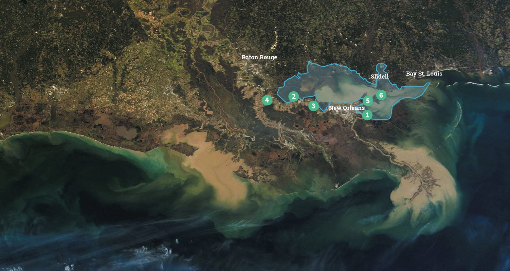
The Pontchartrain-Maurepas Basin is dominated by three large estuarine lakes that are connected by tidal passes, with a fresh-to-salt gradient that runs from west to east. Coastal habitats in the basin include freshwater bottomland hardwood and swamp forest, and fresh, brackish and saltwater marshes. In the upper basin, the swamps are cut off from the nourishing fresh water, nutrients and sediment of the Mississippi River by levees installed for flood protection and navigation. Because of this and the Mississippi River Gulf Outlet (MRGO) shipping channel, these swamps have suffered from saltwater intrusion and are sinking and converting into marsh and open water. Although the MRGO was closed in 2009, restoration of the vast damage due to the MRGO has not been done, and nearby wetlands continue to suffer losses. The freshwater swamps once found in the lower basin have almost completely disappeared due to the lack of river water.
In the upper basin, Union Freshwater Diversion, East Maurepas Freshwater Diversion and Manchac Landbridge Diversion provide fresh water and sediment to the Maurepas Landbridge, which separates Lakes Maurepas and Pontchartrain and provides critical storm surge protection to surrounding communities, including Louisiana’s capital of Baton Rouge. In the lower basin, Central Wetlands Diversion will divert fresh water and sediment to the landbridge separating Lakes Pontchartrain and Borgne. These diversion projects help to prevent the three lakes from becoming a single arm of the Gulf and provide storm surge protection for millions of people. The diversions will also help strengthen and maintain the marsh creation projects, New Orleans East Landbridge Restoration and Golden Triangle Marsh Creation. These marshes will provide important habitat for birds, fish and wildlife and help buffer the new surge barrier on the east side of Lake Borgne.
Our 2017 Coastal Master Plan Priority Projects
Projects in the Pontchartrain-Maurepas Basin Projects
- Central Wetlands Diversion
This diversion will benefit the Central Wetlands Unit ecosystem east of New Orleans, an area destroyed by logging and by saltwater intrusion from the now-closed Mississippi River Gulf Outlet (MRGO). Once primarily a freshwater system dominated by bald cypress swamp and freshwater marsh, the predominant habitat type today is brackish marsh. Regional MRGO-area ecosystem restoration will help rebuild and sustain marsh and swamp, providing storm surge protection for New Orleans and nearby communities. - East Maurepas Diversion
This diversion, planned near Angelina, will provide sediment and fresh water to existing wetlands in East Maurepas swamp. Dominated by bald cypress and water tupelo trees, the Maurepas swamp complex is one of the largest forested wetlands in the nation. However, levees constructed along the river have isolated the area from spring floods and the vital fresh water, nutrients and sediment they bring. This isolation, coupled with rising salinities throughout the Pontchartrain Basin while the MRGO was open, has left the swamp in a state of rapid decline – trees are dying, and young trees are not growing to replace them. The East Maurepas Diversion will benefit the swamp by reconnecting it with the river, aiding the prevention of further wetland loss and the conversion of swamps to marshes, as well as helping to offset future increases in salinity throughout the western Pontchartrain Basin. The fine grain sediment may also increase elevation to a point where there are periods without inundation so that seeds can germinate, perpetuating the forest into the future. - Manchac Landbridge Diversion
Manchac Landbridge Diversion will be constructed within the existing western guide levee of the Bonnet Carre Spillway. Currently, when the Bonnet Carre Spillway is opened to reduce river flood risk in New Orleans, all of the sediment, fresh water and nutrients are directed into Lake Pontchartrain, wasting these vital resources and causing water quality issues. The Manchac Diversion will direct some of these flows into degraded swamps and marshes adjacent to the spillway to increase nutrient input and improve water quality, fostering vegetation growth. Located near Lakes Pontchartrain and Maurepas, the diversion will benefit a variety of habitats, from freshwater forests to brackish marsh. The restoration of these habitats will help St. Charles and St. John the Baptist parishes become more resilient to flooding and storms. The Manchac landbridge is identified by the Army Corps of Engineers (Corps) as a vital landscape feature that serves as a critical line of defense from storm surge for nearly 1.5 million people in eight parishes, especially the Greater Baton Rouge region, but also including the cities of New Orleans, Laplace, Madisonville, Mandeville and Slidell. - Union Freshwater Diversion
Union Freshwater Diversion will convey fresh water from the Mississippi River into West Maurepas swamp near Burnside. Nutrient-rich freshwater inputs to the fresh-forested, flotant and freshwater marsh environments will prevent saltwater intrusion and encourage vegetation growth. The diversion will also convey fine sediment to nourish existing wetlands or create new wetlands in Maurepas swamp. Ascension, Livingston, St. James and St. John the Baptist parishes are all expected to receive flood-reduction benefits from this project. The fine grain sediment may also increase elevation to a point where there are periods without inundation so that seeds can germinate, perpetuating the forest into the future. - Golden Triangle Marsh Creation
This marsh creation project is located near the confluence of two major navigation and shipping channels — the Mississippi River Gulf Outlet (MRGO) and the Gulf Intracoastal Waterway. Dominated by brackish marsh, this area was badly damaged by saltwater intrusion and erosion following the dredging of the MRGO. This project will use sediment from nearby Lake Borgne to create and restore marsh. The restored marsh will help buffer the recently constructed surge barrier, protecting some of the most populated areas of New Orleans, and will eventually provide important estuarine habitat for Lake Borgne. - New Orleans East Landbridge Restoration
This large-scale marsh creation project is located in eastern New Orleans on a landbridge separating Lake Pontchartrain from Lake Borgne, which is the major control on the potential flow of hurricane surge into Lake Pontchartrain. The exposure to wave energy and storm surge has resulted in rapid retreat of the shoreline and the expansion of ponds and lakes within the marsh. The New Orleans East Landbridge Restoration project will create and restore marsh via a sediment conveyance pipeline. The project area includes the Fort Pike State Historic Site, U.S. Highway 90 and the Bayou Sauvage National Wildlife Refuge, the largest urban refuge in the nation, which provides significant estuarine habitat. The New Orleans East Landbridge is identified by the Corps as a critical landscape feature that serves as a crucial line of defense from storm surge for nearly 1.5 million people in eight parishes, including the cities of New Orleans, Laplace, Madisonville, Mandeville and Slidell.