Using the Mississippi River to Build Land at Fort St. Phillip
The Fort St. Phillip Crevasse in Plaquemines Parish resulted from the Mississippi River Flood of 1973, one of the largest floods ever recorded. Levee failures upriver in St. Louis, Missouri led to three out of four of the lower Mississippi’s floodways being operated to reduce flood pressure against levees, maintain navigation along the river and protect nearby communities.
About 20 miles upriver from where the toes of the Mississippi’s Birdsfoot Delta meet the Gulf of Mexico, the river breached the east-bank natural levee connecting the river and Breton Sound, forming the Fort St. Philip Crevasse.
Like nearly all of Louisiana’s coast, the Fort St. Philip area lost land between 1956 and 2008. A 2014 study linked the breaching of the Mississippi River levee and crevasse channel development at Fort St. Philip with some of the land loss in the area, but also acknowledged that a myriad of things, such as storms, sea level rise, and subsidence, also contributed to loss in the area. Wave energy and high subsidence rates plague the wetlands surrounding the lowermost part of the river, making building and sustaining land difficult.

Figure from: Summary Report of Supplemental Analysis -Pictorial Accounting Of Landscape Evolution Of The Crevasses Near Fort St. Philip, Louisiana – 2008 To Present.
Land-building near the mouth of the river isn’t easy, but a recent supplemental report to that 2014 study suggests that more than 1,000 acres of land was gained in Fort St. Philip area between 2008 and 2017, increasing the land in the study area from around 2,000 acres to 3,000 acres. Shifting water levels and tides make an accurate calculations of land change difficult. This study used satellite imagery from 2008 when water levels at the Empire Tide gauge and two coastal reference monitoring stations (CRMS) were low compared to the imagery from 2013 and 2017 which were similar to each other.
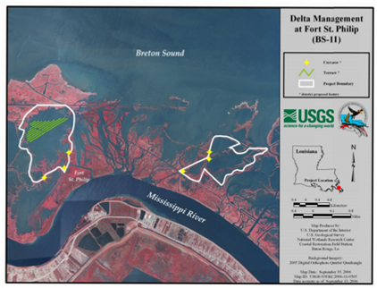
Figure shows the Coastal Wetlands Planning, Protection and Restoration Act Project Map for Delta Management at Fort St. Philip (BS-11).
The growth of land in this area probably isn’t that much of surprise for people who visit the area frequently. Some of the successful land gain in this area can be attributed to a Coastal Wetlands Planning, Protection and Restoration Act Project, Delta Management at Fort St. Philip (BS-11). Constructed in 2006, this project built terraces in the open water of eastern Bay Denesse to trap sediment and also cut six crevasses to connect channels carrying sediment-laden river water with shallow open water areas to enhance growth of emergent marsh. The success of this project is undeniable, and there are many hunters and fishermen that can attest to the productive habitat this project has helped create. However, this project, along with the other land that has recently emerged in the Fort St. Philip area would not have happened without a steady flow of river sediment from the Mississippi River.
While across Louisiana, land continues to disappear, the land growth in the Fort St. Philip area is a testament to the power of the Mississippi River to build and maintain land, using the deposition of its own water, silt and sediment to layer new wetlands and vegetation growth.

Satellite images of the terraces in Bay Denesse near the Fort St. Philip crevasse in December of 2006 and 2016. Water levels are these two times were roughly the same.