50 Years of Building New Land For the Wax Lake Delta
It’s been 50 years since the Wax Lake Delta began to emerge from open water. The delta continues to grow and thrive today, providing a living laboratory to study what is possible when we let the river build new land.
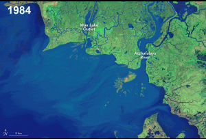 Right now, the flow of the Mississippi River is hardly more than a trickle due to the low rainfall throughout much of the river’s enormous watershed. However, in 1973, rain and snow fell throughout the same watershed, causing the river to rise and sending great torrents of water flowing through Louisiana toward the Gulf of Mexico. When the flood waters finally receded months later, something marvelous was discovered— new land was suddenly visible in Atchafalaya Bay at the mouth of the Wax Lake Outlet.
The Atchafalaya River is the last major distributary of the Mississippi River, branching off the mainstem 200 miles upriver of New Orleans. In the mid-1800s, a log jam removal in the Atchafalaya River allowed it to carry more and more of the Mississippi River’s flow. The Wax Lake Outlet was dredged by the Army Corps of Engineers in 1942 to divert water from the Atchafalaya River to lower water levels in Morgan City. In the 1960s, the Army Corps constructed the Old River Control Structure, which maintains a steady split of water flow – 30% of the combined flow of the Mississippi and Red Rivers goes down the Atchafalaya and 70% goes down the mainstem. The Wax Lake Outlet captures a little less than half of the Atchafalaya River’s flow, and in recent years, has typically averaged more than 100,000 cubic feet per second.
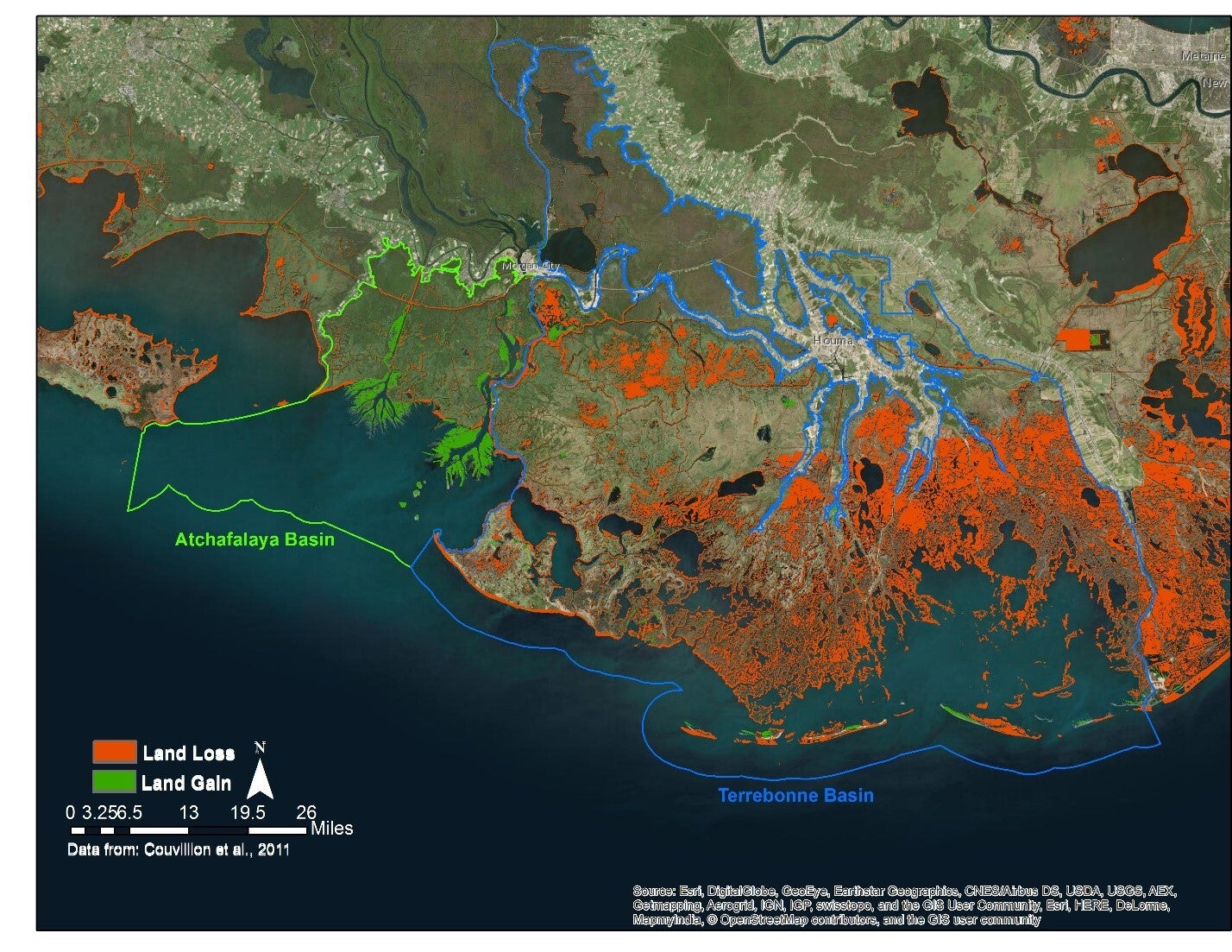
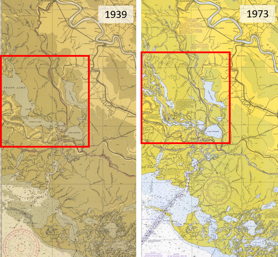
Even before land began emerging from the mouth of the Wax Lake Outlet and Atchafalaya River, the sediment carried by these two channels was building land farther up in the basin, almost completely filling in the once large Grand Lake (previously known as Lake Chitimacha), as well as much of Wax Lake. Sediment was also being deposited in Atchafalaya Bay, building up underwater over time and finally emerging after the 1973 flood. Unlike the Atchafalaya Delta, which includes islands of material dredged from the Atchafalaya River, the Wax Lake Delta is natural. Today, the Wax Lake and Atchafalaya Deltas continue to grow while the Terrebonne Basin continues to lose land every year.
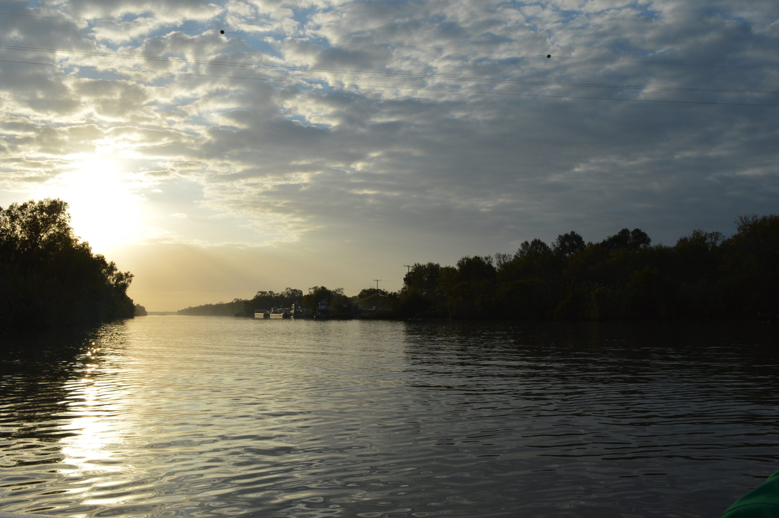
The Wax Lake Delta is one of two places where the Atchafalaya River, a distributary of the Mississippi, flows into the gulf. In 1941, a channel dug to reduce flooding in Morgan City inadvertently formed this delta. It is one of the only growing deltas in South Louisiana. The outlet is not dredged for navigation, so it carries silt into the wetlands which builds up the land. The Wax Lake Delta provides scientists with the opportunity to study early delta formation and has inspired the construction of sediment diversions on the Mississippi River. Saint Mary Parish, Louisiana. Photo by Ben Depp.[/p]
The Atchafalaya and Wax Lake Deltas are part of the Atchafalaya Wildlife Management Area and Game Preserve. Teeming with life, including fish, birds, alligators, and even the occasional Louisiana black bear, these thriving deltas provide abundant opportunities for hunters, fishers, kayakers, birdwatchers and scientists. The growing Wax Lake and Atchafalaya Deltas provide an opportunity for researchers from around the world to study how a river builds a delta. Recently, NASA, as part of their Delta-X project, has been conducting on-the-ground measurements and airborne flights in the Atchafalaya and Terrebonne Basins to calibrate models to forecast which parts of the Mississippi River Delta will better survive with rising seas.
In addition, the Atchafalaya Basin is currently being considered for designation as a National Estuarine Research Reserve. The designation would provide annual funds for onsite science exploration and would be the first such reserve in Louisiana.
It’s now been 50 years since the 1973 flood, when the delta began to emerge and grow from the mouth of the Wax Lake Outlet. While the outlet was never intended to build land, it’s doing just that, and it can help us understand what is possible when it comes to planned sediment diversions projects. Taking the lessons learned from Wax Lake Delta and applying them to other at-risk areas is critical to the future planning and restoration of Louisiana’s coast.