CPRA received 95% E&D documents for lake rim drainage structures. Advertisement expected April 2025. 30% E&D for marsh creation/nourishment portion of the project slated for June 2025, with 95% E&D expected October 2025 and advertisement December 2025.
About This Project
Project ID: CS-0087
Parish: Cameron
Type: Combination Projects, Hydrologic Restoration, Marsh Creation
From the 2024 Annual Plan
Calcasieu-Sabine Large-Scale Marsh and Hydrologic Restoration
Formerly Calcasieu Ship Channel Salinity Control Measures Project
FY 2025 Status: In Construction
Funding Source: RESTORE
FY 2025 Expenditure: $14 million
Estimated Cost: $264 million
Land Benefit: 2,000+ acres
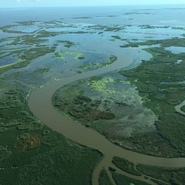
Description: The Calcasieu-Sabine Large-Scale Marsh and Hydrologic Restoration Project (CS-0087) includes 1) large-scale marsh drainage improvements that reduce the flood stress that is currently driving marshvulnerability and 2) large-scale marsh creation and nourishment that increases elevation capital in some of the most degraded areas of the 65,000 acre Cameron Creole Watershed.
This project replaces the discontinued Calcasieu Ship Channel Salinity Control Measures Project. The former version of this project was reevaluated before the 30% design milestone was complete, as real-time data did not reflect what the models were predicting for this project and area. Through additional data collection and modeling analysis, new project goals and solution sets were considered and eventually assembled into a new restoration strategy. New analysis confirmed that saltwater intrusion was not the primary issue to consider, but rather flood stress, and as such the salinity barriers originally included in the project plans were dropped from the project. Remaining funds from the original project were then reallocated to what is now the Calcasieu-Sabine Large Scale Marsh and Hydrologic Restoration project. This project contains three main components:
- Drainage structures with backflow prevention and/or pumping systems to improve marsh drainage
-
Conveyance improvements to facilitate flow of excess water to drainage structures
-
Large-scale marsh creation and nourishment to increase elevation capital

Project Updates
- 01/31/2025
- 10/21/2024
30% E&D completed for lake rim drainage structures in late July 2024. 95% E&D scheduled for January 2025. Bid advertisement estimated for early 2025.
- 07/03/2024
30% E&D for lake rim drainage structures near completion. 95% E&D scheduled for November 2024.
- 03/07/2024
Joint Permit Application submitted to OCM/USACE for lake rim drainage structures and marsh creation / nourishment areas.
- 01/10/2024
Finished 15% design for lake rim drainage structures, 30% E&D activities underway.
- 07/11/2022
Finished design optimization and beginning 15% E&D.
- 09/23/2021
Grant amendment is received in the amount of $28.68 million.
- 06/09/2021
Treasury approves Multiyear Implementation Plan in April and can now proceed with amending the grant.
- 03/02/2021
CPRA Submits Multiyear Implementation Plan to Treasury after CPRA Board approval.
- 12/09/2020
Project renamed Calcasieu-Sabine Large-Scale Marsh and Hydrologic Restoration; CPRA announces public comment period for draft second amended RESTORE Act Multiyear Implementation Plan. Restore the Mississippi River Delta submitted a comment letter.
- 11/06/2020
Salinity barriers not carried forward and dropped from project.
- 08/01/2019
Project put on hold; Coastwide Reference Monitoring System (CRMS) data showing different results than what model is showing; ultimately need more clarity on what hydrologic strategy to use.
What is a Hydrologic Restoration Project?
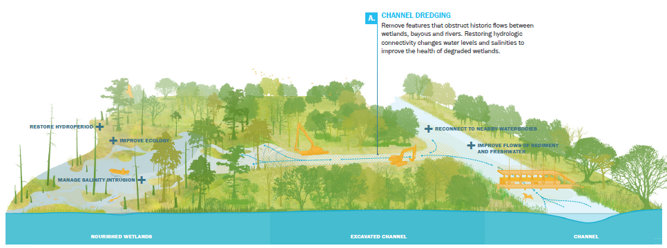
Graphic by SCAPE, published in 2023 Coastal Master Plan.
Hydrologic restoration improves freshwater flows to reduce or prevent harmful saltwater intrusion. These projects control salinity levels, preventing the die-off of freshwater plants and trees. Hydrologic restoration projects can also help maintain optimal salinities needed for the success of other restoration types, such as oyster reef and marsh creation projects.
Other Hydrologic Restoration Projects
Houma Navigation Canal Lock Hydrologic Restoration | Mermentau Basin Hydrologic Restoration | Three Mile Pass Marsh Creation and Hydrologic Restoration
What is a Marsh Creation Project?
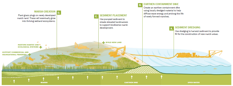
Graphic by SCAPE, published in 2023 Coastal Master Plan.
Marsh creation or “dredging” uses sediment from the Mississippi River, nearby water bottoms or offshore shoals to build land in shallow, open water areas, typically where land has been lost. These projects can build land fairly quickly, but will eventually fall victim to the same process that caused the land to disappear originally. This type of project can be used in conjunction with sediment diversions to trap sediment, and sediment diversions can lengthen the lifespan of marsh creation projects by providing a continual source of sediment to the new marsh surface.
Other Marsh Creation Projects
Large Scale Barataria Marsh Creation | New Orleans East Marsh Creation | Central Wetlands Marsh Creation and Diversion | Three Mile Pass Marsh Creation and Hydrologic Restoration | Delacroix Marsh Creation | East Bayou Lafourche Marsh Creation | Calcasieu Lake Marsh Creation | Belle Pass-Golden Meadow Marsh Creation | Golden Triangle Marsh Creation
Supporter Spotlight
Voices of the Coast - Laurie Cormier, Calcasieu Salinity Project
