Battered by Recent Hurricanes, Southwest Louisiana Benefits from New Coastal Restoration Projects
This is the third blog in a series focused on coastal restoration projects advancing across Louisiana’s coast. You can read the Southeast blog here, and the Central Coast blog here.
In August of 2020, Hurricane Laura made landfall as a Category 4 hurricane in Cameron, Louisiana, located along the state’s southwest coast. Less than 45 days later, Hurricane Delta made landfall as a Category 4 hurricane just east of Cameron in Creole, Louisiana. These storms devastated the people and communities in the region; to this day, many are still in the process of trying to recover.
To better protect people from future storms and sea level rise, it is critical to advance projects that restore and bolster the natural ecosystem, which in turn can serve as an important line of defense for communities, levees, and other structural and non-structural solutions.

Green Heron’s are one of the many species of birds that can be found in southwest Louisiana (Photo Credit: Mike Daniels, APA)
Louisiana’s southwest coast – stretching from the Teche/Vermillion Basin to the Sabine Lake at the Texas/Louisiana border – is part of the Chenier Plain. The Chenier Plan ecosystem has a series of oak-forested ridges that are separated by muddy fresh and brackish marsh. These ridges and marshes were formed from sand, silts, and clays from the Mississippi and Atchafalaya Rivers pushed west along the coast by wind and river flow. The Chenier Plain is important for wildlife with 360 different species of birds using the habitat it provides.
Like most of Louisiana’s coast, the Chenier Plain has experienced land loss, losing 188 square miles since 1932.[i] In addition to hurricanes, this land loss has occurred due to sinking and compaction of the land (subsidence), sea level rise, shoreline erosion and saltwater intrusion due to the alteration of water flows by roads and blockage of natural drainage channels.
However, there are significant investments in projects that are in progress to restore the Chenier Plan and reduce risk for the people and wildlife of southwest Louisiana. These include:
This is joint project between the U.S. Army Corps of Engineers and the Louisiana Coastal Protection and Restoration Authority that is currently in engineering and design and elements of this project will soon begin construction. This project will include risk reduction measures, such as elevating houses and flood proofing non-residential building. The ecosystem restoration projects include nine project that, combined, will restore and nourish more than 12,000 acres of wetlands: five shoreline protection projects that will benefit 5,000 acres, preservation of a historic oyster reef in Sabine Lake, two hydrologic and salinity-control projects to improve freshwater flows and reduce saltwater intrusion, and a Chenier reforestation program to control invasive species and plant trees on 1,400 acres. This project received $125 million earlier this year through the Infrastructure Investment and Jobs Act to elevate 700 homes.
The purpose of this recently constructed project is to restore the health and function of 22,000 acres of marsh and open water by increasing freshwater flow from the Gulf Intracoastal Waterway (GIWW) into coastal wetlands to improve freshwater flow into the area and increase productivity. In addition, to the freshwater structure, this project includes shoreline protection along the GIWW to prevent erosion as well as terraces and small, segmented ridges that can trap sediment over time.
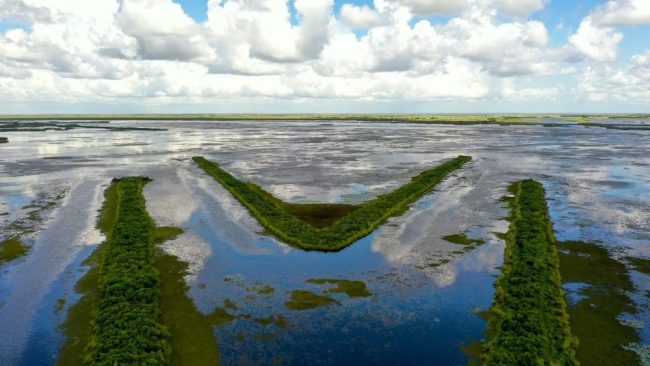
This project, which is in construction, will restore 330 acres of marsh using sediment from the Gulf of Mexico and construct 18 acres of terraces. This will reverse the conversion of wetlands in the project footprint to open water and the terraces will help reduce erosion by waves.
Cameron Meadows Marsh Creation Area (Photo credit: CPRA)
This project is currently in construction to create and nourish 450 acres of marsh using sediment dredged from the Gulf of Mexico. The goal of this project is not only to restore wetlands, but also to reduce saltwater intrusion and marsh loss in the area.
This project is currently in engineering and design and once constructed will create and nourish 400 acres of marsh using sediment dredged from maintaining the Freshwater Bayou canal. This project will help restore a critical wetland buffer between the large, open water areas on either side of the project area.
As the region continues its recovery from recent storms, these projects and investments are absolutely critical to strengthening communities’ ability to withstand future storms, sea level rise and other climate threats.
Louisiana’s Coastal Master Plan includes a suite of restoration and risk reduction projects that seek to protect regions across Louisiana’s coast from Chalmette to Cameron.
Help be a voice for communities in Southwest Louisiana and across our coast by signing up to be a coastal restoration project champion in the years ahead: