Hurricane Ida and Flotant Marsh: An Initial Look at the Storm’s Impacts to Louisiana’s Wetlands
Hurricane Ida made landfall August 29, 2021, near Port Fourchon, bringing maximum sustained winds of 159 miles per hour and destruction to many coastal communities in south Louisiana, including Ironton, Pointe-au-Chien, Grand Bayou Village and Houma. Hurricanes have always threatened coastal residents, but the rapid loss of Louisiana’s wetlands over the past century have left these communities more and more vulnerable with each passing year.
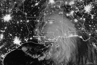
Hurricane Ida on August 30, 2021. Image from NASA
Coastal wetlands can act as a buffer as storm surge from hurricanes moves inland, but they can be damaged in the process. Sometimes they recover. Sometimes they are lost forever.
Satellite imagery taken just a few days after Ida, suggests extensive loss of wetlands in the western part of the Barataria Basin near Larose, Louisiana. The wetlands in this area were battered by the strong side of the hurricane and were particularly vulnerable to wind, currents, and waves produced by hurricanes due to the nature of these wetlands and their underlying soils. The wetlands in this area are fresh to brackish marsh (meaning the salinity generally ranges from fresh to up to about 15 parts per thousand) and much of this area has historically been classified as “flotant” marsh.[1],[2]
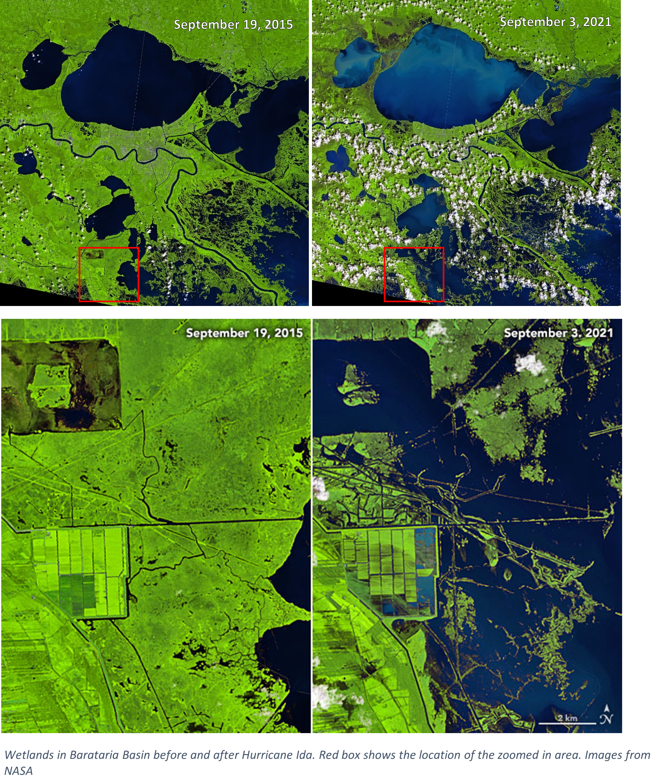
Flotant marsh is made up of floating mats of vegetation that can look like solid marsh, but the vegetation isn’t firmly attached to the soil underneath. Floating marshes can vary in the type of plants that are dominant, thickness of the mat of plants and roots (from a fragile thin mat that sinks easily to a thick mat that can support the weight of a person), and the time the marsh mat floats (continuously to seasonally).
The soil underneath the floating marsh mats has very little mineral sediment, like that from the Mississippi River, and low soil strength.[3] This means that when a strong hurricane passes through the area, these marsh mats aren’t strongly anchored to the soil beneath them and can be rolled up, broken apart and moved around as large mats or “marsh balls”, or compressed like an accordion.
In some cases, this flotant marsh is pushed into a new area and may be able to survive, but many marsh areas will likely not recover.[4]
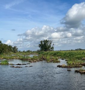
Post-Ida flotant marsh near the David Pond Freshwater Diversion 10/14/2021
There are also marshes in this area that are not flotant, but are attached to low-strength soils, making them more likely to erode during storms. Without a consistent source of mineral sediment coming into the area, it is unlikely marsh vegetation will be able to re-establish.
Not all freshwater marshes in Louisiana are flotant, but in many areas across Louisiana’s coast, freshwater marshes also have highly organic, weak soils. But not all freshwater marshes have weak soils. In the Wax Lake Delta, mineral sediment from the Atchafalaya River has built a thriving delta that supports freshwater vegetation. Despite many hurricanes passing through that region, the marshes haven’t experienced significant permanent wetland loss.
It will take time to understand the full extent of land loss due to Hurricane Ida. Preliminary estimates from satellite imagery from USGS suggest 106 square miles of land have been lost.[5] However, this number will likely decrease over time as satellite imagery reveals what wetlands are able to bounce back from the storm’s impacts and what have been permanently lost.
The one factor that been shown time and time again to create more resilient wetlands that can help protect communities and can recover from hurricane damage is mineral sediment from the river.
[1] Sasser, C. E, Materne, D. M., Visser, J. M, Holm, G. O., and Evers, E. (2007). “Restoring Freshwater Floating Marsh in Coastal Louisiana.” Louisiana Agriculture, 50(2), 14–17. https://www.lsuagcenter.com/~/media/system/1/a/7/7/1a779d326214d03c9117c590632838e9/laagspring2007.pdf
[2] Russell, R. J.. (1942). Flotant. Geographical Review, 32(1), 74–98. http://doi.org/10.2307/210360
[3] Sasser, C. E, Gosselink, J. G., Swenson, E. M, Swarzenski, C. M., and and Leibowitz, N. C. (1996). “Vegetation, substrate and hydrology in floating marshes in the Mississippi river delta plain wetlands, USA.” Coastal Ecology Institute, Center for Coastal, Energy, and Environmental Resources, Louisiana State University, Baton Rouge, LA 70803, USA; 2U.S. Geological Survey, Baton Rouge, Louisiana, USA;3 Oregon Division of State Lands, Salem, Oregon, USA.
[4] Morton, R. A., and Barras, J. A. (2011). Hurricane impacts on coastal wetlands: A half-century record of storm-generated features from southern Louisiana. Journal of Coastal Research, 27(6A), 27-43.
[5] Couvillion, B. 2021. Hurricane Ida Impacts to Wetlands and Land Change Analysis. Louisiana Coastal Protection and Restoration Authority Board Meeting, November 17, 2021. https://coastal.la.gov/wp-content/uploads/2021/11/CPRA-board-Post-Ida-11-17-21-Leigh-Anne-Share.pdf